INTRODUCTION
Samburu covers an area of approximately 20,089km2. It borders Baringo and Turkana County to the west, Marsabit County to the north, Isiolo County to the east and Laikipia County to the south. The County can be divided physiographically into the following major units: Leroghi plateau which rises to over 2000 m, Nyiru and Ndoto mountains and Mathews range with altitudes of between 1,500 and 2500 metres. There is also the eastern flank of the Rift Valley and the plains slopping towards Lake Turkana, Marsabit and Isiolo, ranging in altitude from 1000 to 1350 metres. The climate of the County varies with altitude. Annual rainfall ranges from below 400 mm in the lowlands to over 1250 mm in the mountains. Eight percent of the County is classified as high rainfall with adequate moisture to support arable agriculture. The rest of the County is classified as rangeland.
The major occupation of the indigenous population is livestock production. The livestock population as per the 2009 population census is comprised of 184,666 heads of cattle, 550,750 goats, 387,698 sheep, 32,824 camels, 26,822 donkeys and 37,749 indigenous chicken. In addition there were 4,962 commercial chicken, 21,057 beehives and 187 pigs. In this County, whose proportion of ASAL is about 92 per cent, livestock have the ability to withstand severe fluctuations in weather patterns and environmental shifts and, therefore, provide both food and income security. Livestock are often one of the most important sources of cash income for livestock keeping households. Livestock keeping employs the majority of people and is by far the largest source of revenue generation in semi-arid Samburu County.
The capital investments proposed for RPLRP Samburu County were:
- 1 borehole in Nairimirimo, Samburu East
- 1 livestock market in Latakweny, Samburu North
- 1 hayshed in Nomotio farm, Samburu Central
- 1 borehole in Lengarde, Samburu East
- 1 livestock market in Baragoi, Samburu North
- 1 water pans in Lerata
- 1 water pan in Nairimirimo, Samburu East
- 1 rock catchment in Ngurunit, Samburu North
- 1 grain warehouse in Lolmolok, Samburu central
- 1 breeding Boma in Nomotio, Samburu Central
- 1 livestock market in Lpus, Samburu East
- 1 poultry house in Nkaroni, Samburu East
Achievements under thematic areas
Toggle content goes here, click edit button to change this text.
Samburu County is generally water scarce. The main water sources for domestic and livestock are boreholes, pans, dams, shallow wells, rock catchments, roof catchments and springs.
RPLRP supported drilling and equipping of boreholes, construction and rehabilitation of water pans, rock catchments and rehabilitated five rural water supplies under the Emergency Response Action Plan (ERAP).
Achievements
| 1. | Construction of 1 water pan in Lerata |
| 2. | Construct of 1 borehole at Lengarde |
| 3. | Construct 1 hay shed in Nomotio |
| 4. | Rehabilitation of 1 water pan in Nairimirimo |
| 5. | Construction of 1 rock catchment at Siang’an |
| 6. | Distribution of 1,560kgs of pasture seeds to farmers |
| 7. | Conducting of WUA trainings |
| 8. | Rehabilitation of Lesidai Water Pan – ERAP |
| 9. | Repair of Lorumoki, Lolguniani, Lengei and Ngeju Emuny boreholes – ERAP |
| 10 | 532 acres of pastures planted |
Siang’an Rock Catchment
Siang’an is located in the far end of Samburu North Sub County bordering Laisamis in Marsabit. It is under Ndoto ward, Arsim location and Ngurunit Sub location. The area has 102 households as per records available in area Chief’s Office and with an assumption that each household has 5 (five) members, the population could be estimated to be (102 households by 5 members) which totals to 510 people.
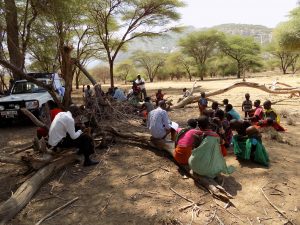
Community consultation meeting in Siangan
The existing rock catchments were constructed by the Christian Blind Mission (CBM) and Standard Chartered Bank. It was established in the year 2008 to curb the problem of water shortage in the area. These two rock catchments which are adjacent to each other serves the Siangan community members for a period of six (6) months when fully filled.
The rock catchment is currently being run by the members of the community who makes sure it is clean and well maintained. It is immediately surrounded by the following villages; Naloja, Piripindo, Keno, Siangan, Ntepes, Langatananyukie, Maragi.
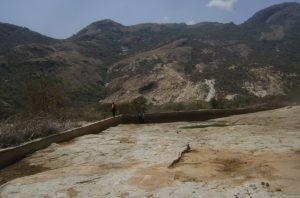
Old Siangan rock catchment before a new construction by RPLRP
Livestock Species Population Estimates
The community members contacted during the CMDRR meetings agreed upon the establishment of the catchment since it was the only source of water available for them and their animals . The average population as estimated by the community representatives for each species is as shown in the table below:
Livestock Species Population Estimates
| Species | Population Estimate |
| Goats and Sheep | 6700 |
| Cattle | 1200 |
| Camel | 250 |
| Donkey | 150 |
Facts and figures
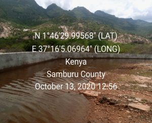
Completed Siangan rock catchment
Nairimirimo Borehole
Nairimirimo location has four (4) Sub-Locations namely – Laraiti, Lorok Onyukie, Swari & Olmar Maroi. Human population in the seven villages can be approximated as follows: Soit (100), Nki (200), Ndonyo (50), Maron (200), Nalkapur (50), Lkwaasi (300), Letoole (100), and Nairimirimo primary school (250). Total human population is approximately 1,250. Livestock Population on the other hand include 2,000 Cattle, 1,000 Sheep, 6,000 Goats and 1,000 camels.
Nairimirimo location of Wamba North Ward is a water scarce area. Efforts have been made to put up a permanent water source over the recent past but has remained futile. The area residents and the livestock in the area only accessed water from Seiya river which is around nine kilometers from Nairimirimo primary school. Therefore, water scarcity remained a big challenge to local residents, livestock and the school going children in the area. It is as against this backdrop that RPLRP Samburu, through consultation with the stakeholders and the County government of Samburu, approached the community with the proposal to put up a borehole in the area. Several meetings were held with members who represented the community. The community members said that previous hydrological surveys had led to drilling of 2 bore holes with depths of 60 metres and 100 metres respectively in Nairimirimo without getting any water.
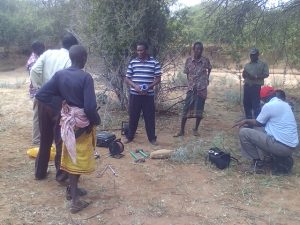
Hydrogeological survey with members of Nairimirimo community
There was virtually no source of water available to Nairimirimo School. It had been on the verge of closure severally due to water shortage. The nearest private borehole has low yield with salty water which is unfit for both human and livestock consumption. The borehole is equipped with a hand pump which has since then broken down.
There also exist four (4) seasonal water pans with only one (1) that hold water for up to three (3) months. The other three (3) hold water for only three (3) weeks. The community members, the school children and teachers all depend on these water pans as their major source of water. The risks of water borne diseases’ out break have been reported in the area. The school management was encouraged to erect water tanks on all roof structures to maximize on roof water catchment whenever it rains to supplement other sources of water available.
The team comprising of the community representatives and the technical team then started searching for the possible sites for water drilling & conservation. They finally got the site with the above specifications in Nairimirimo. The Regional Pastoral Livelihoods Resilience Project (RPLRP) alleviated the water shortage by drilling a borehole in Nairimirimo.
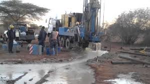
Drilling of Nairimirimo borehole
The community is generally in support of the investment. This can be confirmed from their attendance of the various consultation meetings whenever they were called upon. The Nairimirimo community also participated actively in the hydro-geological survey. The community proposed that the water from the borehole needs to be supplied to Nairimirimo primary school in order to improve access by both the community and the school. The County leadership as well as the area political leadership fully supports construction of the borehole in the area. The community also agreed with the specific area proposed by the hydro-geologists.
Nairimirimo Water Pan
Nairimirimo area is located in the lowlands plains of Wamba east area. Nairimirimo water pan serves the entire Nairimirimo Sub-location (Samburu East) and some parts of Samburu Central and North Sub-counties. The community members within this region have a large population of livestock (cattle, sheep, goats, camels and donkeys). Efforts to put up a sustainable water source have been ineffective due to lack of committed donor. The current water pan used by the residents has been a failure since it cannot hold water for more than a month after the rains; it is located in a highly porous ground thus leaving the locals to vulnerability of water shortage within the rest of the months. The community members expressed the need to put up a water pan to improve the livestock quality in the area and provision of clean water for domestic use.
Nairimirimo water pan proposed for rehabilitation by RPLRP
The technical staff visited the water pan that had water and recommended that it be fenced, de-silted and expanded to provide more water to community members for both livestock and domestic consumption. It was also recommended that water troughs and other facilities be sited away from the water pan to minimize contamination. Other protective measures like planting trees around the water pan were also suggested.
The project heeded to the community proposal to rehabilitate the water pan for it to be a sustainable water source. Rehabilitation of this water pan entailed:
- Construction of pipe draw off system
- Construction of spillway concrete sills
- Construction of cattle trough
- Construction of communal water points.
- Fencing of the reservoir as described in the bill of quantities and technical drawings.
- Construction of two door pit latrine
- Construction of two silt traps with seals.
The project was fully funded by RPLRP with the continuous community engagements in all the stages of this project.
The site was selected based on:-
- Its large catchment area and land formation
- The land was readily donated by the community
- The area has soils with suitable properties for water retention and embankment construction
- It is the path of drainage channel.
- The land was idle apart from being a grazing ground
1. Lerata Water Pan
Lerata village of Koiting Location is located in Waso ward of Samburu East Sub-county, Samburu County in northern part of Kenya. Lerata village is located about 50km to the South East of Wamba town the Headquarter of Samburu East Sub-county and a few kilometres (about 15) to Archer’s town. Lerata is hot and dry and the area is often subjected to strong winds. The main livelihood in Lerata is Sub-location is pastoralism. The main livestock reared include cattle, goats, sheep and camels. The area is generally water deficient; the only source of water for both human consumption and livestock use is a borehole which is of low yield hence unable to meet the demand. Other water infrastructures in the area are three water pans which are currently dry and silted hence unable to hold any water for use during dry seasons. There are no Rivers, rock catchments nor springs in the area.
construction works in Lerata water pan
Other than drought, livestock which is the main livelihood faces challenges of disease outbreaks, water shortages and wildlife conflicts especially during dry periods. Lack of livestock market, mobile network and human diseases are the other challenges facing the area. For school going children school operations are seriously affected as parents migrate with their children in search of water and pasture. Market operations are totally disrupted as there are few or no livestock to sale or few buyers.
The sub-project has created employment opportunities especially for those who are involved in the pan construction. The continued existence of the sub-project in the area ensures availability of water for the households and the targeted schools, ensuring that the population in Lerata village remains water and food secure. The pan construction improves the quality of livestock by reducing trekking distance hence generating higher income.
Water availability at close distances has created time for women to engage in other activities that have improved food availability at the household level. It has also created opportunities for kitchen gardens in the home compounds. Availability of water through the pan have freed children to attend classes hence improving school attendance.
FACTS AND FIGURES
1. Lengarde Borehole
Lengarde community is a homogenous Samburu pastoral community of about 3,000 people, consisting of 1,000 youth, 1,000 adults (100 of them elderly) and 1,000 children. Gender issue was addressed through a deliberate involvement of women in the community.
During the initial stages of the project, RPLRP was keen on having communities reflect on their challenges and find solutions to them. Their elders brought Lengarde to the attention of RPLRP. A visit by county government and other partners was quickly organized. The situation that the team found was heart breaking: women walked over 20 km carrying water, while driving livestock. They woke up at 3 a.m. to walk to River Seiya where they dug sand wells to access unclean water. Children went to school at 11 am because they had to fetch water.
Women walking with water on their backs while driving livestock
The site is situated for Lengarde Borehole is located within Lengarde Sub-Location, Wamba East Ward, and Samburu East Sub-County of Samburu County. It lies within the Survey of Kenya topographic sheets for 79/3. Its defining coordinates in UTM are 0292355E and 0118669N (Figure below). The area is served by the Wamba – Swari road, although most of the areas in the sub location are served by foot paths
GIS imagery of Lengarde area in Samburu East
Water from the borehole is being used for domestic and livestock purposes within the Lengarde community. The livestock population is made up of approximately 20,000 sheep and goats, 5,000 cattle, 2,000 camels and 2,500 donkeys, thus the total water requirement is estimated at 20m³/day.
The partners include County Department of Water, County Department of Livestock mainly. At Lengarde RPLRP facilitated the formation of Water Users Association committee which composition entails both gender. The role of the committee is to management the facility on behalf of the community. They have a monthly fee for basic maintenance as agreed by the community as a whole. Both gender are active in this process. People living with disability are equally beneficiaries as they sit and decide in this committee. Other vulnerable groups such as widows and youth headed households are given equal access to the facility.
Training of Lengarde water users association on the management of the water facility
Several meetings were held. After the introduction, they developed a write up using CMDRR in which they identified their problem clearly. Using this process, they were able to prioritize, and the water problem was highest on the agenda. The facilitators of the CMDRR dug deeper using different methods, such as discussions to extract traditional knowledge
Community consultation meeting at Lengarde primary school
Afterwards, the community was fully consulted in identifying the site for constructing the borehole, and a screening exercise was done. NEMA experts discussed the effects of the borehole on water and pasture, while the representative from the Ministry of Environment considered the possible impact on the environment. A feasibility study was done to ensure that the project could be realized. This then went to the donor for consideration. Finally, engineers came to the site and handover was done for drilling.
Each step in the drilling process was unique and the community was closely involved: They divided roles, provided some labour and local expertise for drilling construction and fencing. The steps include the Community-managed disaster risk reduction exercise. Community included both gender in a third gender rule proportion in the committee. The other step was Feasibility and screening exercises that were also fully participatory in terms of vulnerable groups.
The main stakeholders of Lengarde borehole were the user community, the County water department, the County livestock department being core. RPLRP facilitated the post drilling and construction review for standard check, which was confirmed to work well. From initial stages test pumping was carried out and construction was allowed to go on. After completion the facility was allowed some time to be run by the community then handing over was done after ascertaining that there was no technical or methodological hitches. Currently the community of Lengarde is enjoying a 14-20Km reduction in previous water distances, the young stock is also increasing survivability while women, children, and other vulnerable groups in Lengarde have had relief from stresses associated with water distances and access.
Currently Lengarde borehole is yielding 5 cubic litres of water hourly according to County directorate of water. From County director of livestock about 1500 livestock are drinking water daily from the facility, and about 500 households fetch drinking water daily.
FACTS AND FIGURES
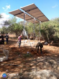
Lengarde borehole 32M3 tank and pump house
Toggle content goes here, click edit button to change this text.
Toggle content goes here, click edit button to change this text.
Toggle content goes here, click edit button to change this text.